Thursday, December 4, 2008

Pagudpud - The Future Famous Tourist Destination

Pagudpud is an enormous place to visit if you're Pagudpud - The Future Famous Tourist Destinationlooking for the comparatively perfect charms of the Philippines. Pagudpud is a wide and beautiful town on the northwest tip of Ilocos Norte, Luzon, bounded to the south by the town of Bangui and to the east by the Cordillera Mountain Range, the town of Adams and the province of Cagayan. The South China Sea lies to the west and north.


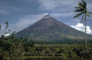
It is considered the largest island in the Philippines. The hills and mountains are luxuriant, the valleys productive. It lies 45 miles north of Laoag City, the provincial capital, and about 350 miles north of Manila -- about the equal distance between Los Angeles and the San Francisco Bay Area. Creeks, streams and waterfalls splash the landscape and spill into the South China Sea. All around, the ocean and sky are awash in varying shades of blue.


Pagudpud is approximately 500 kilometers from Manila, which is 12 hours straight drive by car, or about 15-18 hours with three major stop overs and some minor picture takings along the way.


On your way there you will surely enjoy the travel passing through Hacienda Luisita in Tarlac (Take the first stop-over here, there are lots of restaurants outside the Luisita gate). Be careful driving along the highway in the town of San Manuel, about 10-15 km after Luisita gate it is accident prone area.


After 5 hours drive from Manila, you will find yourself entering the province of Pangasinan via towns of Carmen-Urdaneta, and then you will pass by the town of Sison Pangasinan.


When you are in Agoo, you are half way on your trip to Pagudpud.


When you are in Vigan you are about 80% the travel to the breath taking views of Pagudpud “a Boracay 25 years ago” where one can marvel at the deep blue sea on your left while driving in the highway, see a forest-like hectares of coconut tree plantation (planted just feet away and side by side ) and of course the world famous white beaches.


Pagudpud Beaches, 2 hours north of Laoag City, has powder-white sand, but it's hard to tell which is bluer: the sky or the sea. While you are making up your mind, you might also consider a stop in Pasuquin, where the famous biscocho (Ilocos biscuit) is a favorite take-home delicacy for local visitors. But don't forget to check your watch, for while you play in the waters of Pagudpud, you may not notice how much time you have spent on these delightful shores, which are at the very tip of Luzon Island.


Here are some tips on going there:

1. Take at least three 45 minute major stop-overs; Luisita in Tarlac, Agoo in La Union and Vigan in Ilocos Sur.

2. Take pictures of the old churches.

3. an alternate driver every 2 or 3 hours drive will prevent driving fatigue.

4. Visit the remains of Former president Marcos in the town of Batac ilocs norte. That is right before Laoag City. Also, do not fail to drop by Fort Ilocandia, the only five-star hotel in the northern part of the Philippines.

5. Enjoy the small restaurants in Laoag, Ilocos Sur. Cherish the Ilocano Longganisa both in Vigan and Laoag.

6. To fully enjoy your vacation, spend some 3-5 days or a 2-4 overnight stay from Vigan to laoag to Pagudpud.


PAGUDPUD! The future famous tourist destination. Make it a memorable, once in a lifetime escapade.


Other pictures of Pagudpud

Pagudpud - The Future Famous Tourist Destination Pagudpud - The Future Famous Tourist Destination
Pagudpud - The Future Famous Tourist DestinationPagudpud - The Future Famous Tourist Destination

Sunday, November 16, 2008

Siargao Island - The Hidden Tropical Jewel

Surigao del Norte is a medley island in the northeastern Siargao Island - The Hidden Tropical Jeweltip of Mindanao. A province that has managed to preserve its natural marvel through the years. On the eastern side of the province is Siargao Island, a hidden tropical jewel of the Pacific that hosts one of the most beautiful beaches in the world and home of wave surfing and the famous CLOUD 9, the latest sport and tourist attraction to take the country by storm It is the Surfing Capital of the Philippines. The best known surfing break now with a world reputation of being in the top Surfing Waves in the world, is nick-named "Cloud Nine". But there are literally scores of breaks down this coast, and every time a surfing expedition is mounted in the area, more new breaks are being discovered.


Siargao is a tear-drop shaped island situated 800 kilometers southeast of Manila in the province of Surigao del Norte. It has a land mass of approximately 437 kilometers. It has a land mass of approximately 437 kilometers. The east coast is relatively straight with one deep inlet-Port Pilar with a coastline marked by a succession of reefs, small points and white sandy beaches. There are similar neighboring islands and islets with similar landforms. The reefs and points are excellent for picking up any swell that comes along turning into clean, fast waves. The Island's Pacific-facing reefs are situated on the edge of the Philippine Trench, and the extremely deep offshore waters guarantee the ocean swells have undiluted power when they encounter the many coral and rock reefs, giving Siargao excellent surfing conditions, particularly during the southwest "habagat" monsoon from August to November, when the prevailing wind is offshore.


Siargao Island, faces the Pacific Ocean and the Philippine Deep, the second deepest water in the world, at more than 11 km below sea level. The area is pure tropics with the plenty activities including snorkeling, island hopping, waterfalls, swimming holes and of course awesome waves and friendly locals.


This right-breaking reef wave is the site of the annual Siargao Cup, a domestic and international surfing competition sponsored by the provincial government of Surigao del Norte. The wave was discovered by travelling surfers in the late 1980's, and named and made well-known by American photographer John S Callahan, who published the first major feature on Siargao Island in the US based SURFER Magazine in March 1993, and hundreds of photos in many other books and magazines since. Callahan has returned to the island many times since his first visit in 1992, and his efforts to photograph and publish surfing related and general location material from Siargao islandin books and magazines around the world has put the island on the international map and drawn thousands of surfers and tourists to Siargao island.


There are several other excellence waves on Siargao and nearby islands, but Cloud 9 has received more publicity than any other wave in the area, indeed in the Philippines as a whole. It is the only wave in the area easy to get to without a boat, leading to overcrowding and the nickname of "Crowd 9" among surfers worldwide as keen foreign and locally owned accommodation and tourist facilities attempt to profit from the magazine publicity and the annual arrival of visitors drawn by the Siargao Cup competition in September.
Siargao Islands contain the biggest mangrove forest reserves in Mindanao on the opposite coastline. Long stretches of wetlands equally indicate potentials for commercial seaweed propagation. Siargao Island is greatly influenced by the winds and currents coming uninterrupted from the Pacific Ocean, intensified by the Mindanao current running westward through the Siargao Strait.


Offshore, a classic tropical island lay secluded within its surrounding coral reef and the dozen coconut palms dressed in the center circle of the island crackle gently in the morning breeze. Off to the right, well within the massive coastal reef, lay a shining white sand bar some 200 meters long, maintained by a group of some forty black-headed terns that stood chattering among themselves at the waters edge. The tide of Siargao is diurnal with tidal curves typically present especially on the east coast of the island.via


How to get there?


Manila - Cebu City - Surigao City -Siargao Island

Manila - Surigao City
Air via Asian Spirit
Sea by SuperFerry, Sulpicio
Land by Philtranco Bus


Manila to Cebu
Air via Philippine Airlines, Cebu Pacific, Air Philippines
Sea by SuperFerry, Sulpicio


Cebu City - Siargao Island
Air via SEAIR


Cebu City - Surigao City
Air via Asian Spirit
Sea via Cokaliong ,SuperFerry, Sulpicio


Surigao City - Dapa (entry point Siargao Island)
Sea via Fastcraft Aska and Fortune Jet


Dapa - Gen. Luna (beach & surfing area)
Land by van / motorbike / jeepney


Sayak (siargao airport) - Gen. Luna (beach & surfing area)
Land by van / motorbike / jeepney


Manila - Butuan City - Surigao City - Siargao Island

Manila to Butuan
Air via Philippine Airlines, Cebu Pacific, Air Philippines


Manila to Cebu City
Air via Philippine Airlines, Cebu Pacific, Air PhilippinesSea by SuperFerry, Sulpicio


Cebu City to Butuan City
Sea by SuperFerry, Sulpicio, Cebu Ferries


Butuan City - Surigao City
Land by Private Van, Bus, Jeepney
Surigao City - Dapa (entry point Siargao Island)
Sea via Fastcraft Aska and Fortune Jet


Dapa - Gen. Luna (beach & surfing area)
Land by van / motorbike / jeepney


Sayak (siargao airport) - Gen. Luna (beach & surfing area)
Land by van / motorbike / jeepney


Other pictures of Siargao Island, Philippines.

Surfing at Siargao IslandNaked Island at Siargao
Cottage in Siargao IslandWhite Sands in Siargao Island


Video of Siargao Island, Philippines


Sunday, November 9, 2008

Mayon Volcano – The Perfect Cone

Mayon Volcano – The Perfect Cone

The Mayon Volcano is an active stratovolcano in Mayon Volcano – The  Perfect Conethe Philippines on the island of Luzon, in the province of Albay in the Bicol Region. The near perfectly cone shaped volcano is situated 15 kilometres northwest of Legazpi City.


Mayon Volcano is one of the candidates of the New 7 Wonders of Nature. Its summit measures 2,421 meters above sea level (masl) while its circular base has a radius of about 48 kilometers. Mayon Volcano is surrounded by five (5) municipalities and three (3) cities with a total land area of 5,775.70 hectares. Its symmetrical form at any horizontal direction made this volcano a truly scenic wonder.


Mayon is a stratovolcano or composite volcano. The current cone was formed through pyroclastic and lava flows from past eruptiond. Mayon is the most active volcano in the Phillipines, having erupted over 47 times in the past 400 years. It is located between the Eurasian and the Philippine Plate, at a convergent plate boundary: where a continental plate meets an oceanic plate, the lighter continental plate overrides the oceanic plate, forcing it down; magma is formed where the rock melts.


Like other volcanoes located around the rim of the Pacific Ocean, Mayon is a part of the "Pacific Ring of Fire". It is renowned as the "Perfect Cone" volcano because of its almost perfectly conical shape.


Other pictures of Mayon Volcano.

Mayon Volcano – The  Perfect ConeMayon Volcano – The  Perfect Cone

Thursday, October 9, 2008

Chocolate Hills in Bohol

The Chocolate Hills is an unusual geological Chocolate Hills in Boholformation in Bohol, Philippines. Probably, it is Bohol's most famous tourist attraction. They look like giant mole hills, or as some say, women's breasts, and remind us of the hills in a small child's drawing. Most people who first see pictures of this landscape can hardly believe that these hills are not a man-made artifact. However, this idea is quickly abandoned, as the effort would surely surpass the construction of the pyramids in Egypt.


It is composed of around 1,268 perfectly cone-shaped hills of about the same size, spread over an area of more than 50 square kilometres (20 sq mi). They are very uniform in shape and mostly between 30 and 50 meters high. They are covered in green grass that turns brown during the dry season. From this color, the hills derive their name. At other times, the hills are green, and the association may be a bit difficult to make.


According to the legend, it that the hills came into existence when two giants threw stones and sand at each other in a fight that lasted for days. When they were finally exhausted, they made friends and left the island, but left behind the mess they made. For the more romantically inclined is the tale of Arogo, a young and very strong giant who fell in love with an ordinary mortal girl called Aloya. After she died, the giant Arogo cried bitterly. His tears then turned into hills, as a lasting proof of his grief.


However, up to this day, even geologists have not reached consensus on how they where formed. The most commonly accept theory is that they are the weathered formations of a kind of marine limestone on top of a impermeable layer of clay. If you climb the 214 steps to the top of the observation hill near the complex, you can read this explanation on a bronze plaque.


How to get there


Plenty of tourist guides and tour operators will be happy to bring you to the chocolate hills, either as a separate trip or as part of a day tour. However, if you want to go here on your own, from Tagbilaran, you will have to go the integrated bus terminal in Dao and catch a bus going to Carmen. If you look like a stranger, you will have a hard time not finding one. At the entrance of the bus terminal people will point you to the right bus. Make sure it is the first one to leave, and ask the driver to drop you off at the Chocolate Hills complex, about 4 kilometers before the town of Carmen. From there it is a 10 minute walk along a road winding up to the complex.


To get back to Tagbilaran, you will have to walk back to the main road, and wait for a bus to pass by. The last bus from Carmen to Tagbilaran leaves at four P.M. Alternatively, you can use the services of the motorcyclists who often wait here for tourist, and ride 'habal-habal,' or motorbike taxi.


If you're coming from Tubigon (arriving from Cebu by boat), a few buses go to Carmen daily, but sometimes you'll have to wait for some time for the bus to fill up. When you arrive in Carmen, you can catch the next bus or jeepney in the direction of Bilar, Loay or Tagbilaran, or ask a 'habal-habal' driver to bring you to the Chocolate Hills Complex.


Where to stay


If you would like to stay in the Chocolate Hills, you have very little choice. The only facility is the Government run Chocolate Hills resort. Currently, this hotel is undergoing renovation and extension, but, since funds have run out, work on this is suspended, and you'll have to deal with the mess of a half-completed resort. However, the staff are friendly, and if you stay here overnight, seeing the sun rise over this bizarre landscape is worth the inconvenience. The place also has a still functional and maintained swimming pool, which is behind the unfinished building, a little bit downhill.via


Video of Chocolate Hills

Philipine Hot Spots – Chocolate Hills, Bohol

Friday, October 3, 2008

About Philippine Hot Spots

This site offers information about top tourist spots in the Philippines and serves as reference and resource information about the country.

Philippine Hot Spots Pictures


Philippine Hot Spots Pictures


Philippine Hot Spots Link Partners

Please email us if you want exchange link with.